
Vereda da Ponta de São Lourenço (PR 8)
32.742979, -16.701537
This 6 km trail (3 km return) will take you to discover the eastern tip of the island, with panoramic views over the north and south sides.
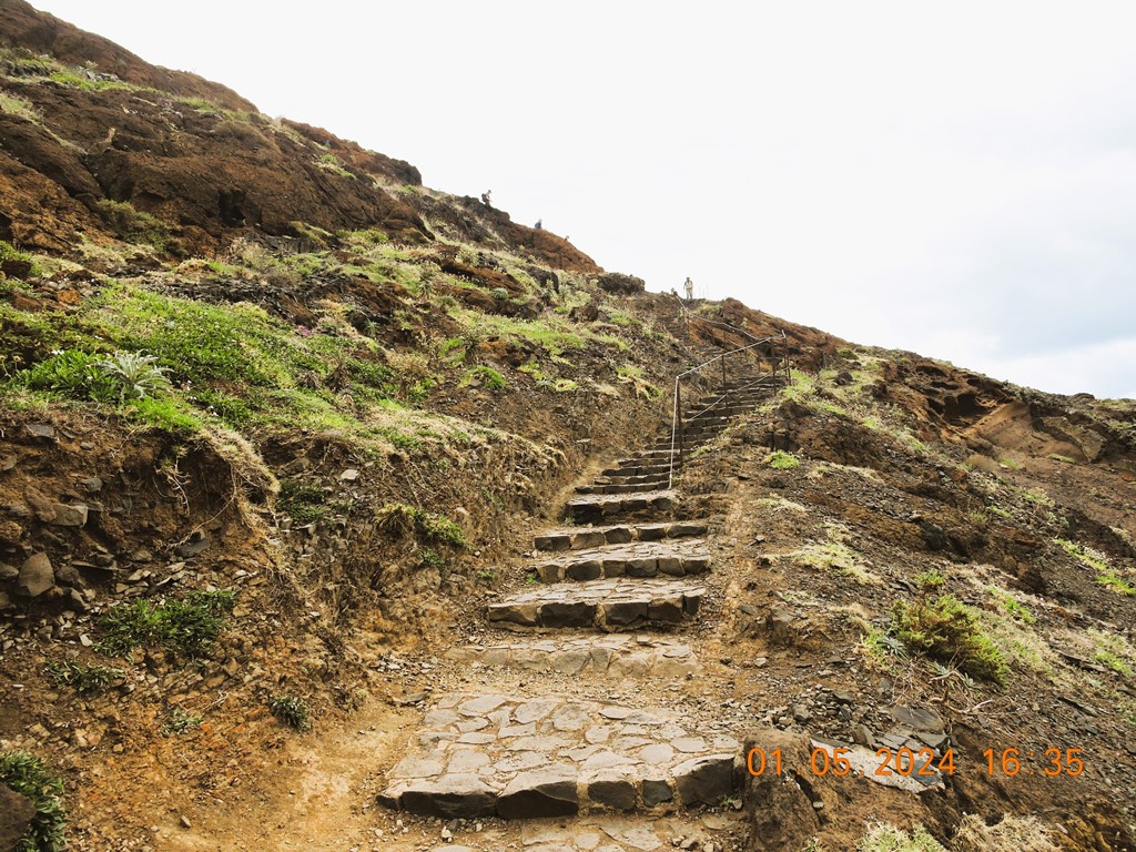
PR 8 - Vereda da Ponta de São Lourenço is a trail of moderate difficulty, with an estimated duration of 2:30 hours, which goes along the peninsula with the same name.
Although it is an undulating path, the good conditions of Vereda da Ponta de São Lourenço offer a pleasant hiking experience.
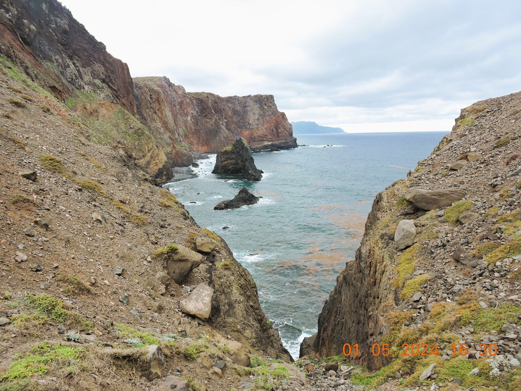
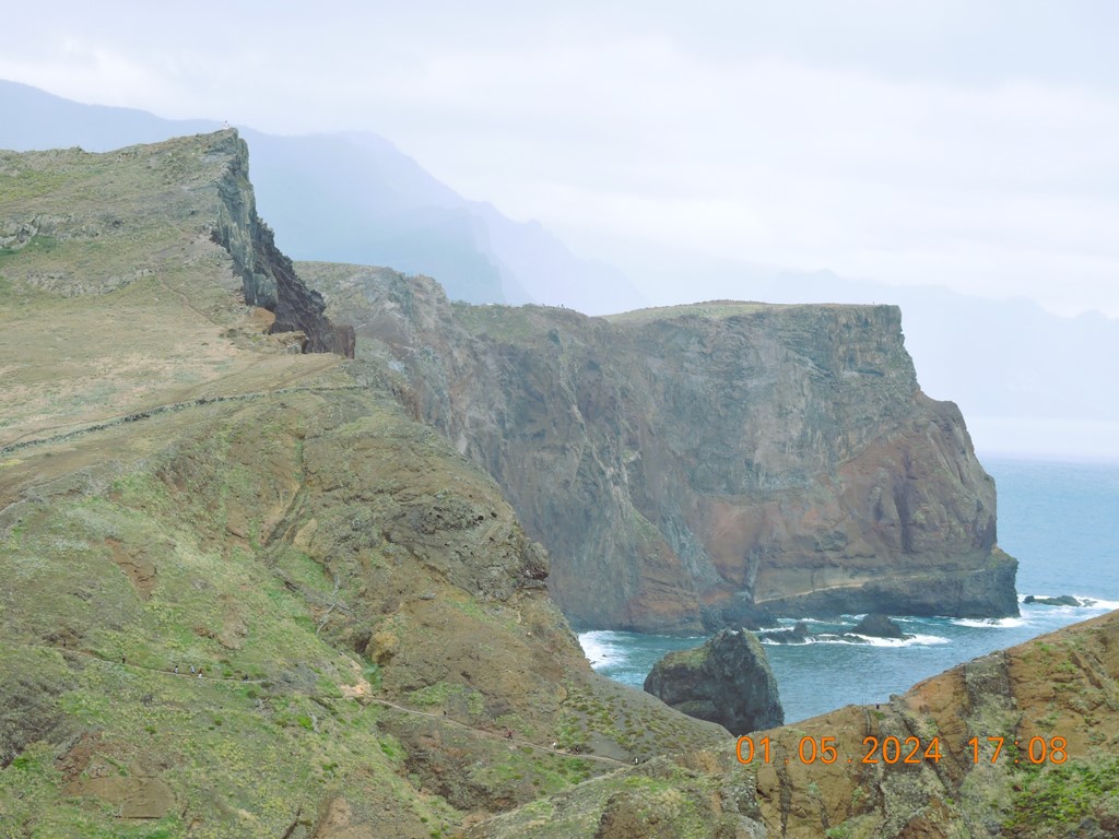
It is a peninsula of volcanic origin, mostly made of basalt, but with some limestone sediment formations.
At the end of it, there are two islets: Desembarcadouro Islet and Farol Islet.
The semi-arid climate and exposure to northern winds explain the low vegetation and the absence of trees in this place, contrasting with the rest of the island.
It is classified as a Partial Nature Reserve heritage site, home to rare plants and a diversified fauna.
Besides one of the largest colonies of seagulls in the region, and protected seabirds such as shearwaters and Bulwer's petrels, at Vereda da Ponta de São Lourenço you may, with some luck, observe marine species in their habitat, namely the monk-seal.
At the end of the walk along Vereda da Ponta de São Lourenço, enjoy a well-deserved swim at Cais do Sardinha.
Details
Distance: 3 km (6 km round trip)
Difficulty: Moderate
Duration: 2:30 hours
Start/End: Baía d'Abra / Casa do Sardinha
Max. altitude/ Min. Altitude: 126 m / 23 m
Note: Entry - €1, except residents and children up to 12 years old (included).
Please access the SIMplifica website for more detailed information.


Another of the best trails and levadas in Madeira is the fabulous Vereda da Ponta de São Lourenço, which develops on a peninsula of volcanic origin that contrasts with the rest of the island of Madeira.
At Ponta de São Lourenço, instead of the lush vegetation, the hallmark of Madeira, you will find a lunar landscape, marked by steep and undulating rocks of brownish, orange, and reddish colors, where only the undergrowth and a small oasis of palm trees remain. This particularity is due to the semi-arid climate and the enormous exposure to northern winds. Along the peninsula, you can also see two islets: Ilhéu da Cevada and Ilhéu do Farol, which, as the name suggests, is the “home” of the Ponta de São Lourenço Lighthouse. The feeling of having traveled to some other island is inevitable!
The walking route is approximately 4 km long (8 km round trip) and extends in a succession of ups and downs along the undulating cliffs of Ponta de São Lourenço. Here you will be able to observe countless rock formations from another planet and will be treated to superb coastal landscapes, with the Island of Porto Santo and the Desertas Islands appearing on the horizon.
Almost at the end of the route, just before the towering Ponta do Furado, you will find Cais do Sardinha, in an idyllic bay with crystal clear waters that invite you to take a refreshing swim, and Casa do Sardinha where you can rest for a while and have a drink before return. A true oasis in Ponta de São Lourenço!
Attention: Ponta de São Lourenço is very windy and has enormous sun exposure. Given this, you should avoid walking during the hottest hours and carry a good supply of water and a good windbreaker. Never give in to the temptation of getting closer to the cliffs. Gusts of wind are very strong and unpredictable. Any carelessness can end in tragedy.


💝💝💝💝💝
SEARCH IN
MACHICO MUNICIPALITY

Return to mainland Portugal and
to the Azores and Madeira islands


No comments:
Post a Comment